Park nearby City Park
Nigeria
Park nearby City Park
City Park
Ahmadu Bello Way, Abuja, Municipal Area Coun, NG Nigeria
contacts phone
:
+234
Latitude:
9.077069
, Longitude:
7.4756665
larger map & directions
read more
nearest Park
934 m
Graceland Gardens and Parks
Abuja
Park
read more
942 m
A Class Park
Kashim Ibrahim Way, Abuja
Park
read more
1.029 km
The Marquee @ FLOREAT Garden
Abuja
Park
read more
1.477 km
Zahgusta Gardens
Abuja
Park
read more
1.503 km
Eden Park And Garden Wuse
Utako District, Abuja, FCT
Park
read more
1.508 km
Matambella Garden
Luanda Close, Abuja
Park
read more
1.549 km
Canterbury Hills Park
Abuja
Park
read more
2.281 km
Accra Street Park
Senanga Street, Abuja
Park
read more
2.285 km
Nook Garden
2016 Dalaba Street, Abuja
Park
read more
2.37 km
Unique World
Accra Street, Abuja
Park
read more
2.614 km
Lansan artificial carpet grass
17 Amazon Street, Abuja
Park
read more
2.729 km
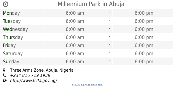
Millennium Park
Abuja
Park
read more
4.063 km
Abuja Park
Abuja
Park
read more
4.713 km
Setraco Park
Abuja
Park
read more
5.267 km
Jabi Park
Abuja
Park
read more
5.488 km
Water fountain park
Abuja
Park
read more
5.974 km
Berger City Park
Jabi Lake
Park
read more
6.386 km
Jabi Garden
Abuja
Park
read more
6.572 km
Preferred Facilities Management
Suite 10A Sabondale Shopping Complex, Plot, 556 Obafemi Awolowo Way, Abuja
Park
read more
6.748 km
Park 24
Abuja
Park
read more
7.498 km
Anafaraa Plaza
Ahmadu Bello Way, Abuja
Park
read more
7.563 km
baba office
E1, Abuja
Park
read more
7.879 km
Dantata & Sawoe Life Camp
E.F Nsefik close life camp, Abuja
Park
read more
📑
all categories
Accounting
Administrative area level 1
Administrative area level 2
Amusement park
Aquarium
Art gallery
Atm
Bakery
Bank
Bar
Beauty salon
Bicycle store
Book store
Bowling alley
Bus station
Cafe
Campground
Car dealer
Car rental
Car repair
Car wash
Casino
Cemetery
Church
City hall
Clothing store
Colloquial area
Convenience store
Courthouse
Dentist
Department store
Doctor
Electrician
Electronics store
Embassy
Establishment
Finance
Fire station
Florist
Food
Furniture store
Gas station
General contractor
Grocery or supermarket
Gym
Hair care
Hardware store
Health
Hindu Temple
Home goods store
Hospital
Insurance agency
Intersection
Jewelry store
Laundry
Lawyer
Library
Liquor store
Local government office
Locality
Locksmith
Lodging
Meal delivery
Meal takeaway
Mosque
Movie theater
Moving company
Museum
Natural feature
Neighborhood
Night club
Painter
Park
Parking
Pet store
Pharmacy
Physiotherapist
Place of worship
Plumber
Point of interest
Police
Post office
Premise
Real estate agency
Restaurant
Roofing contractor
Route
School
Shoe store
Shopping mall
Spa
Stadium
Storage
Store
Subway station
Supermarket
Synagogue
Taxi stand
Transit station
Travel agency
University
Veterinary care
administrative area level 3
sublocality level 1
↑